Friday, January 8, 2010

Desert Daze - A Southwest Adventure (XXV)

Part Twenty-five: Mountains to the Left of Me, Mountains to the Right, Here I Am, Stuck in the Valley - Great View!

On to the Owens, my favorite ‘lower 48’ valley. To get there though I must take Route 190 through the west part of the park and it was closed this morning due to ice and snow in a mountain pass. I stop at the ranger station to check the status - it has been reopened. Yay! What a great road to drive, all twisty and turny with roller coaster ups and downs, and always surrounded by beautiful lonely desert scenery as far as the eye can see that changes with the elevation – everything from creosote bush and mesquite to sage and Joshua trees.


After leaving Death Valley I head north on I-395 through the Owens Valley, the deepest mountain valley in the lower 48 states. In the town of Lone Pine, the elevation rises from 3,733 feet in the center of town to 14,505 feet on the summit of Mount Whitney – that’s an almost 11,000 foot difference!

I can’t help but be in a great mood – I-395 is one of the most scenic drives anywhere and I do love it so. To my left the incomparable Sierra-Nevada Mountains loom like a massive, impressive 400-mile long snow-covered stone wall; several peaks including Whitney top out at over 14,000 feet.To my right the Inyo–White Mountain ranges rise to similar lofty heights (White Mountain tops out at 14,242 feet) but that is about all they have in common, they are arid, brown and look more like big, soft rounded hills than mountains providing a nice contrast to the Sierras.
The Sierras rise muscularly from the valley floor, an impressive escarpment of towering jagged granite spires. They catch and wring out moist Pacific breezes; hundreds of green river and creek corridors spill out of these mountains. Some places in the Sierras regularly receive more than 500 inches of snowfall per year; the town of Tamarack once recorded 884 inches in one winter! That’s 73.7 feet! Another year they received 390 inches of snow in just one month – that’s an average of 13 inches every day in that month!

The Inyo–White Mountains by contrast are in the rain shadow of the Sierras and receive on average less than 12 inches of precipitation a year, most of which arrives as snow in the winter. On a summer's day the amount of precipital moisture in the air is about half a millimeter, the lowest ever recorded anywhere on earth. But these very hardships contribute to these mountains producing trees so old they surpass the majestic Giant Sequoia of the Sierra by more than a millennium! The bristlecone pines are in fact the oldest trees on earth - a specimen of this species nicknamed "Methuselah", is 4,700 years old! Its exact location is kept secret, since an even older specimen, nicknamed "Prometheus", was cut down in 1964.


I practically have ‘The Owens’ to myself. Not many people travel here at this time of year (with one exception, those traveling to ski at Mammoth Ski Resort) because mountain access is limited at best; most of the roads that go up and into the Sierras are now closed, buried in snow and will not reopen until June. But I have no intention of going up into the mountains, I just want to camp at their base and admire them. In my opinion, this is the best time of year to see them, when they’re wearing their full winter coat - from late spring through fall, they look blotchy, kind of like an animal shedding its winter coat.

Next: Wasting Film – Just Can’t Help Myself!

Saturday, December 26, 2009

A Christmas Hike

It has become a ritual. I have no family in the area to get together with (they’re spread out from Florida to Texas to California), so I always go for a substantial hike (a snowshoe if there is enough snow) every year on Christmas or the day after. And this year is no different.

It’s a miserable day out there – temps in the mid-30s with a cold rain pouring down, but that won’t stop me. I lace up my hiking boots, throw on a rain slicker and head out, Sprague Brook Park my destination. There is a most wonderful trail in this park; it follows the ridge high above the creek and its myriad tributaries and has great views but what I really like about it is that it weaves in and out of old growth forest.

I set out at a little after 2pm giving me about 2 ½ hours to complete the 6+ mile hike before darkness sets in. Normally that is plenty of time but today it’s a trudge because there is 3 or 4 inches of mushy snow on the ground making every step a challenge - especially slippery going up or downhill – which is much of the hike.

This is truly a bleak day, the kind they invented the word 'bleak' to describe. The winter sun, which is already low in the sky this time of year, is completely blocked out by thick, gray overcast; the light is so muted it feels like twilight in the middle of the afternoon. To add to the atmosphere, curtains of icy rain blow sideways in the gusty winds; it’s a challenge to keep the hood on my head, the winds try again and again to tear it off. There is no keeping dry, the wet quickly makes its way down inside my boots, jacket and hood; before I know it, I’m wet through and through.

Nevertheless, I’m lovin’ every step! I say a bad day hiking is still better than a week of good days inside. I’m just getting to know this trail as I only discovered it earlier this year so I stop often to marvel in the impressive views and at the plentiful huge old trees. I find a black cherry that I estimate to be at least five feet across (I must remember to bring a tape measure with me next time.) It’s the widest forest-grown (as opposed to field grown where there is no competition for sunlight) black cherry I think I’ve ever seen. This is one massive, impressive tree.

I also find a couple of sugar maples that I guess to be seven feet wide! Then, wandering off trail, I discover a special grove of at least twenty towering old growth sugar maples in one small area - it must be really dark here in the summer when these monsters are fully leafed out, the canopy has to be nearly impenetrable. There are also plenty of other old trees along the trail besides cherrys and maples, other impressive specimans include hemlocks, beeches and birches.

With the rain pattering on my hood and the howling winds I can’t hear much else, so it really startles me when a blue jay suddenly screams from the murk. The first animal encounter of the day. Next, I watch a gang of chickadees flitting from tree to tree, foraging for food. I recall reading somewhere that birds require upwards of 10,000 calories a day – the equivalent of a human eating 150,000 calories! The search for food must be all-consuming task every day for those brave birds that overwinter here in the north.

Now I spy a little bandit digging in the snow. I stop walking. He stops digging. We stare at each other, neither moving a muscle. Then he (she?) slowly ambles over to a tree and begins climbing up. At about ten feet off the ground, he stops and looks at me with curious eyes – what a cute picture! Only I haven’t brought my camera because it’s so wet and windy (I guess I’ll never learn the lesson to always bring it.)

My final wildlife sighting of the day is of a deer down in the gorge that has caught sight of my movement up here on the ridge. We watch each other for several minutes until I raise my hand to salute this beautiful animal and wish it a Merry Christmas. With that, she takes off at a gallop. I love watching those fluffy white tails bob through the forest with the greatest of ease!

I make it back to my vehicle just before dark, soaked to the bone, but content if not cold and a little tired. This has been a wonderful hike, the very best one yet until… the next one of course!

Saturday, December 19, 2009

HAPPY HOLIDAYS!


Sorry I haven't posted anything of late - busy, busy, busy!

Please keep checking back, especially after the first of the year.

Take care and enjoy your holidays!

Dave Reade

Sunday, November 29, 2009

No Pics With This Post

And it’s my own damn fault. I have told myself a million times (OK, maybe just dozens of times) never, ever, go on a hike without a picture-capturing device of some type because one never knows what might present itself. Well, today, because I didn’t listen to that voice, I missed a glorious opportunity.

It’s Thanksgiving Day afternoon and, with family far away and friends celebrating with their own families, I am alone. I decide to go for a hike before it gets dark (way too early this time of year.) It’s a gloomy, overcast, drizzly day but, as soon as I enter the woods, I feel better. I have decided to leave my camera gear behind because, after all, what could I possibly see that’s photo-worthy under these conditions?

I slog through the soggy forest, wet down by a persistent, consistent, but significant pitter-patter of raindrops on fallen leaves, soaked to the bone and splashing through puddles that fill my boots and make them all squishy inside. And it’s chilly, but I do love the forest so, so I don’t mind at all. The trail I’m following was once a road probably used for logging. I can see it stretch off far in the distance ahead of me.

Suddenly I notice a glowing uptrail as if the woods were on fire. The sun has split the clouds and the wet forest is shining, bathed in a golden radiance. I reach the edge of the forest, pop out of the woods and see… a magnificent double rainbow; possibly the most vivid I have ever seen, arching over the meadow, in a full half circle, pots of gold at both ends. Set against dark clouds, it stands out as I have never seen before, just like a rainbow in a children’s book, all glorious, surreal, ideal – but, in this case, the real deal, arching hugely across the sky.

At first, I curse myself for not bringing my gear but then I lapse into a form of paralysis, I can’t move for having to avert my gaze to take a step. It hangs up there for what I would only guess was at least ten minutes while I just stood there, amazed, jaw on the ground, only half believing what I was seeing.

Lesson learned… maybe. At least the image is forever etched into my brain, never to be forgotten, even if I can’t (unfortunately) share it with you.

Sunday, November 8, 2009

Primevil Perceptions

It’s 65 degrees outside today and I’m reveling in it. For Western New York on November 8, this is a full 15 degrees above ‘normal.’ And, for some reason the air smells incredibly sweet too. I’m feeling euphoric - I’m thinking that there must be more oxygen in the air today than usual. Of course, there isn’t, because if the percentage of oxygen in the air were anything more than the normal 21 percent, I and everything else on earth would spontaneously burst into flame and if it were any lower, it would not support life as we know it. I think about how improbable and miraculous life on earth is; everything has to be just right. How is this possible? And why? Ah, big questions – it’s much too nice out to be pondering big questions today.

I’m wondering along the high bluffs above Sprague Brook, in and out of lush old growth forest. In my last two posts I discussed my personal survival, my cat-like existence, now I’m thinking about the survival of the remaining old growth forest here in the east. There isn’t much left; by one account, less than one-half of one percent of the original forest remains. This means that for every 200 acres of original forest less than one acre remains. Quick work considering the architects of its demise have only been here for about 200 years or so.

Allowing anything to fully mature and die a natural death is something that mankind (man unkind?) is not very good at (except, of course, when it comes to himself.) In these days of ever spiraling population and more people demanding a higher standard of living, these trees are more often than not looked at as ‘resources’, valued not for their inherent selves but for what they can provide by cutting their life short – lumber and paper. With this kind of pressure to cut them down, it’s a miracle that any of these primeval places still exist - making the ones that do that much more special.

To me, entering an old growth forest is to be setting foot in a sacred place. Wandering among the ancient trees is a privilege, and I always feel lucky that I have two sturdy legs to carry me into these awesome places. It’s balm for the stressed out soul. I admit that lately I have become obsessed with searching out these places; even finding a small pocket with just a handful of old trees in an otherwise young forest thrills me. And every time I stumble upon a patch of old growth I try to figure out how it escaped the ax while everything around it was being cut down.

Sometimes it’s obvious, like being hidden deep down in the bottom of a ravine or gorge or on a steep slope. Other times there doesn’t seem to be any rhyme or reason to its survival and I just scratch my head and wonder. The truth is that the loggers didn’t miss much unless it was inaccessible, part of protected public land, on a private estate or purposely set aside as a refuge.

Old-growth forests are quiet, hushed places – nature’s cathedrals. The sounds of an ever-noisier world are filtered out here or at least greatly reduced to the point that I believe I can actually hear myself think. I go to the old growth to tackle seemingly unsolvable problems or lift myself out of a depression and somehow, the answers or spirit-lift I need always seems to be waiting for me upon my return from such a place.

Next: Primeval Perceptions: The Search

Saturday, October 31, 2009

A Charmed Life

In my last post, I detailed an adventure in which, while though I didn’t exactly confront it head-on, death was close enough so that I could feel it lurking. To talk about my life so far in any meaningful way it is necessary to mention the compendium of near-death and ‘almost near-death’ experiences I’ve survived. There is a plethora of them and they have affected how I see life profoundly.

There have been so many narrow escapes over the years I could almost write a book about them. To name just a few:

♦ come within a few feet of being broadsided by a speeding tractor-trailer truck that I couldn’t see coming around a curve (my vehicle’s engine hesitated, inexplicable because it was an almost-new rental that didn’t hesitate at all before or after the incident during the entirety of a two week trip)

♦ nearly froze to death in the winter desert (this and the experience above happened the same day!)


♦ skidded to a halt within inches of plowing off a cliff with my truck and trailer in a snowstorm while driving through mountains.

♦ climbed an extremely steep cliff until I was 300 or 400 feet off the ground before realizing that I couldn’t go up any further (blocked by a protruding rock shelf) and that trying to go back down was almost sure suicide.

♦ been held up by a knife-wielding drug-crazed man.

♦ almost froze to death in a northest forest.

♦ been caught underneath a pounding waterfall, not able to tell which way was up and almost losing consciousness.


♦ been in a plane that was both struck by lightning and hit by wind shear as the pilots tried to land it (they couldn’t, we finally had to land at another airport 100 miles way)

♦ realized I was slowly, but steadily being surrounded by 2,000 degree lava pushing its way inexorably down a mountain side in Hawaii and jumping over it at the last minute.


♦ and so on...

Then there was the incident this very morning. I pulled out of my driveway just before dawn to head up to Williamsville to deliver some books. It was a dark and stormy morning; pillowy gray clouds with angry black-bottoms were scuttling across the soggy sky. Rain pelted down and wind gusts heaved me from side to side. As I entered a particularly wide-open stretch of the New York State Thruway, a tractor-trailer truck, suddenly caught broadside by an extreme gust of wind, lost control. The truck jackknifed and careened slowly and smoothly like it was on ice from one side of the road to the other, crashing into both barriers in explosions of sparks before finally winding up sideways in the middle of the highway. All this seemed to happen in slow motion. I hit my brakes and skidded to a halt some twenty feet away; had I been following any closer, well - I’d rather not think about it. Good thing it was early on Saturday morning and traffic was sparse – I wasn’t rear-ended and no one else hit the truck either. I shudder to think about the results if this had happened during rush hour.

This is why I’m convinced I’ve lived a charmed life - so far anyway. These experiences have opened my eyes, ironically allowing me to see life’s magnificence (especially in nature) through coming so close to death. These incidents also inspire me to share what I see and feel through my writing and photography.

And nowhere do I feel the beauty of life more than in old growth forests. Just recently, I have started on a mission to explore what’s left of old-growth forest near my home and eventually in the rest of the Northeast.

Next: Primeval Perceptions

Wednesday, October 28, 2009

Danger Dave Somehow Manages to Find Yet More Danger (Danger Dave Part 2)

Fortunately, there is no problem making it safely back down to the bottom of the hill. What a difference a little elevation can make, down here there is far less snow and the roads are just wet. I head for the Red House entrance; there should be no problem getting into the park that way, the road is wider and the elevation lower.

As I approach the Red House Lake area, I am stunned; it’s a surreal world of fall colors and snow; it’s breathtaking. Better get to work while these conditions last. I shoot various pretty scenes around the lake then decide to hike into the woods to see what the snow accent around Allegany’s only real waterfall, Bridal Falls. By now, the temperature is beginning to warm up and snow rains down from the trees, pummeling me as if I am on the receiving end of a snowball barrage from above. A few times, a heavy blob manages to land squarely on the back of my neck, making its way inside my jacket and shirt, sliding down the skin of my back; brrrrrrr.

The waterfall is just a trickle; I had assumed with all the wet weather we’d been having that there would be more to it; disappointing. As I look around for something else interesting to shoot, I hear the crack! of a gunshot. I am momentarily confused, I know that bow-hunting season begins the next day, but no one should be in the woods hunting today, much less with a gun. Only it’s not a gunshot, it’s a tree limb, cracking off under the weight of the snow and crashing down about 20 feet away in a maelstrom of flying snow and leaves. Yikes! Nevertheless, I soon find myself absorbed in the composition of an interesting scene, forgetting all about the danger of falling limbs and trees when I hear more cracking. This time a whole tree comes crashing down off the embankment down which the waterfall cascades, its roots ripped right out of the cliff by the burden of the incredibly heavy snow. O.K., it’s time to leave, no image is worth being killed for.
As I make my way back, the snow rains down from the trees even harder than before and, by the time I pop out of the woods, I am thoroughly soaked and shivering. Only one solution to this problem, I jump into the truck and blast the heater - ahhhhh, that feels so good. By now, the snow has turned to all rain and the magic has melted. I head home, wet, warm and happy, for I have once again been fortunate enough to have seen the kind of beauty that most people only experience a few lucky times in their lives. Even if it did involve some danger, it was definitely worth it!

Sunday, October 25, 2009

Danger Dave - Part One

This experience occurred on Friday, October 16th; I didn’t post it until the images to go along with it were developed.

I guess by now regular readers of my blog know that I seek out unusual conditions and places that have the potential for capturing unique and exciting photography. Sometimes, by their very nature, these conditions or places lead to increased chances of bodily harm; that is, sometimes the risk factor goes up with the corresponding increased potential for interesting photography; I would soon find out that that would be the case today.

The forecast called for a wet snowfall overnight and I woke up well before dawn excited about the prospects. With many of the autumn leaves still hanging like ornaments in the trees, this could offer some unique scenery – despite our reputation for snow here in Western New York, it is not common in mid-October when the leaves are at their most colorful.

I look outside; sure enough, a layer of snow has blanketed the trees and ground. With the temperature hovering around freezing and the forecast calling for a gradual warm-up, I know these conditions won’t last long so I decide to hedge my bets; I head south to higher elevations, to Allegany State Park where the temperature should be a few degrees colder and these promising conditions may last a bit longer.

Fortunately, the roads are still warm and the snow is not sticking to them so I make good time. I head up the winding, twisting north entrance road into the park just as dawn’s early light begins to reveal the towering forest on both sides of me. This road tops out at about 1,000 feet higher in elevation than back home and the closer I get to the top the deeper the snow gets; slipping and sliding now in the icy slush, I switch into four-wheel drive.

Unfortunately, this same heavy wet snow that increases the potential for interesting photography also increases the likelihood of downed tree limbs and branches. Limbs and even entire trees are sagging precariously under the weight of the cement snow and several times, I have to thread the needle between bent or fallen trees to keep making progress. Alas, rounding a bend I witness a tree slowly shuddering to the ground right in front of me. Naively, I think I can get out and move it – not a chance; it’s a bigger tree than I thought and it’s completely blocking the road. Nothing to do but turn around and go back down the way I came, hoping that another tree hasn’t fallen in the meantime caging me in.

Next: Danger Dave Somehow Manages to Find Yet More Danger (Danger Dave Part 2)

Wednesday, September 30, 2009

Desert Daze - A Southwest Adventure (XXIV)

Part Twenty-Four: Willow Creek Canyon Falls and the Bighorn Sheep

(First time reading this 'Desert Daze' story? Scroll down to 'Older Posts' to start with Part One)

Or rather, his skeleton, but I’ll get to that…

For the second waterfall hike of the day, I tackle Willow Creek Canyon. The first section of the route is pure drudgery; it’s more than a mile across a vast, ankle-twisting alluvial fan before even reaching the canyon mouth. (An alluvial fan is an outspread, gently sloping mass of alluvium [rocks and sand] deposited by a stream, especially in an arid or semiarid region where a stream issues from a narrow canyon onto a plain or valley floor. Viewed from above, it has the shape of an open fan, the apex being at the valley mouth.) There is not even a hint of water here, just rocks, sand and more rocks and sand.

When I finally do reach the mouth of the canyon and enter it, there is still no sign of water. I hope the waterfalls are running since that is the whole point of this hike. After about another three-quarters of a mile of trudging through shifting sand and loose rock, the canyon abruptly narrows into not much more than a deep crack in the mountain wall. Not long after that, water magically appears in the form of a pretty, little gurgling stream, the music of which reverberates pleasantly off the canyon walls. I realize now that the water was with me all along but deep down in the sand whereas here there is only solid rock, nowhere for it to hide.

With the discovery of water, my enthusiasm is now rekindled and I practically sprint up the narrow defile until I reach my goal – the waterfall.


There it is and it’s a nice one, spilling and splashing down a fifty foot wall. I’ve read that there is a way up and around the waterfall, with more waterfalls upstream but this is the end of the hike for me, I’ve done enough today and I’m not about to attack a fifty foot wall.

I’ve enjoyed two waterfalls in one day in otherwise bone-dry Death Valley, who would’ve thought? I turn to go back, but as I turn, something in my peripheral vision causes me to look right. There, at the base of the wall is a skeleton! It’s of a bighorn sheep! I guess even these normally surefooted animals slip once in a while. Before today, I hadn’t even realized that bighorn sheep inhabited Death Valley, I thought they only lived in much colder climes - but here lying at my feet was irrefutable evidence to the contrary.


With my hiking and solitude urges satisfied for the day, I leave the waterfall and skeleton behind and trudge back through all that sand and rock to where I started. At least this way is downhill. Finally, I spy Hotel Truck waiting patiently in the distance for the next adventure. When I reach ‘er, I climb in, start ‘er up, and get back on the road pointing ‘er west towards my next destination: the deepest mountain valley in the lower 48.

Next: Mountains to the Left of Me, Mountains to the Right, Here I Am, Stuck in the Valley - Great View!

Thursday, September 17, 2009

Desert Daze: A Southwest Adventure (XXIII)


Part Twenty-Three: Death Valley Waterfalls

(First time reading this 'Desert Daze' story? Scroll down to 'Older Posts' to start with Part One)

A river runs through it. No really – as I drive across the park, each time I reach a low point in the road, a stream is running across it causing me to have to slow down, as the water is up to a foot deep in places. Bizarre, considering where I am.

Almost all the other roads in the park are still closed - washed out, sand covered or, in the case of higher elevations, snowy and icy. These conditions deny me access to most of the park and make me a little claustrophobic. After a week and a half of solitude and open spaces, of seeing few vehicles and even fewer people, this feels like a small city – hustle and bustle, traffic and people milling about - all trapped in this one section of the park.

As mentioned in an earlier post, I no longer visit most National Parks because they have become so crowded they no longer feel wild at all. (I call the valley portion of Yosemite “Yosemi-City”; there is no longer a ‘slow season’ there to visit, just always lots of vehicles spewing exhaust with long lines of traffic commonplace.) DV has never suffered this problem because it’s vast and, with the exception of today, visitors are usually spread out over the entire park.

Therefore, I need to escape. My plan: I’ll hike to a couple of remote waterfalls. Waterfalls you say? In DV? No, not the extremely temporary kind created by all the rain whose lives can be measured in hours, but one that is year-round and another that, fed by snowmelt from the surrounding mountains, runs for about six months of the year. Both hikes are upstream and long enough to discourage those who aren’t willing (or able) to make the effort – and that’s most people – so I’m assuming I’ll encounter few others. I’m right; in fact, I do not see another soul in either location. I have my tranquility back.

I decide to hike to Darwin Falls first. This waterfall is truly an anomaly in the middle of the desert. It's fed by the China Garden Spring high up in the hills which consistently produces enough water to supply the creek and falls all year (along with the nearby tiny settlement of Panamint Springs.) I make my way upstream towards the falls through luxuriant growth that effectively shields the creek bed from the parched desert all around it. If I had somehow been plopped down here with no clue as to where I was and without seeing the surrounding desert, even my wildest guesses probably wouldn’t include DV.

I spy a pipe running alongside the creek – it’s no larger than a few inches in diameter. The entire water supply of Panamint Springs runs through this conduit. I reach the falls. A single ‘fall’ charmingly splits into two as it makes its way down the rock face. Small by almost any standard, these falls may as well be Niagara Falls to me today - I think they are just spectacular. Surrounded by lush growth - trees, shrubs, and even several hanging fern gardens

and with birds high up in the trees singing praises of the place, I feel like I have found the mythical Garden of Eden. I sit down in the shade to eat my lunch serenaded by the always alluring melodies of falling water and beautiful birdsong – in the middle of the desert - magical!

Next: Willow Creek Canyon Falls and the Bighorn Sheep

Wednesday, September 2, 2009

Trees and the August 9 Storm, cont’d.

So, what about the trees? I hadn’t had a chance to go hiking since the storm and didn’t see many trees down while driving around town so I just assumed there wasn’t much of that kind of damage. I was wrong. On a recent hike through the forest near my house, I found plenty of trees down, some yanked right out of the ground, root ball and all and others snapped off. A good number of these trees were quite large and had weathered many a storm before succumbing to this one; it was obvious that it had been particularly violent.

An undisturbed forest with few holes in its canopy can usually weather storms pretty well. This is because any particular tree can only bend as far as the tree next it and that tree as far as the one next to it and so on, providing a natural stopping point for each. However, where there are holes in the canopy, some trees have nothing to ‘lean on’, and, especially, from late spring through early fall when they are fully leafed out, powerful winds can catch a tree top and bend it so far that something has to give – it either uproots or the trunk snaps. The forest near my house had been selectively logged in the not too distant past and obviously suffered the consequences of holes in its canopy from this storm.

In contrast, yesterday I had a chance to walk through some old-growth forest, untouched by the hand of man. This forest is full of magnificent trees, some with trunks three, four and even five foot wide and attaining heights of over 100 feet – here the canopy was mostly unbroken. What a difference. I had to look hard to find any damage from the storm at all.

But I did notice something weird that affected both forests - the ground had been swept clean in many places, the leaves and branches that usually litter a forest floor were gone, even on gentle slopes –somehow it just looked naked. I have hiked in forests a gazillion times in my life and had never seen such a clean sweep; the storm rainfall rate and quantity must have been incredible. According to the National Weather Service, the town of Perrysburg (near Gowanda where there were devastating floods) received six inches of rain in about an hour and a half – an amount and rate on par with hurricanes and tropical storms!

So where did all the leaves and branches go? Into the gullies and ravines. There, I found great tangles caught on tree trucks, roots and rocks; in some places the piles were as tall as me! The storm of August 9 significantly changed the look and feel of local forest landscapes for some time to come.

Friday, August 28, 2009

Trees and the August 9 Storm

If you’re from Western New York you most likely remember the storm of August 9, 2009. It blew through here (quite literally) in the evening, dumping an incredible amount of rain and producing a spectacular light and sound show. If you live in Gowanda or Silver Creek, you will remember this storm for a long, long time. Many people in those areas were flooded out, and, in Gowanda, a wall of mud joined the water. The town was closed to traffic for a week, there was so much to clean up.

I had the great fortune to be driving home from an art show that evening. It was one of my scariest drives ever, even including white-knuckle drives on ice and in blizzards. I literally stayed with the storm the whole way as it drifted from north to south across Erie County. The constant flashing made it seem like daylight much of the time. The thunder was so close, so deep and powerful, it felt like I was inside a giant subwoofer. The rain was coming down so hard, I had my wipers on high and still, they often couldn’t keep up. And even though I was naturally going slow, a couple of times my tires hydroplaned and I was surprised when I didn’t slide right off the road.

Due to flooding roads were being closed right behind me. The north and west accesses to my road were both closed. I’m lucky I made it home. The sense of relief I felt when pulling into my driveway was indescribable, let’s just say I was mighty thankful I had made it home. But it wasn’t over yet.

The power was out. I grabbed my headlamp that I keep right by the door for just such emergencies and made my way into a pitch black house. Great, with the power out I wouldn’t be able to shower (I have a well) and I was a sweaty mess, so I poured myself a glass of wine and sat by the windows watching the light show continue outside. Suddenly, my skin prickled and I had the eerie sensation of what it must be like to stick your fingers into an electrical outlet. The next moment, thunder and lightning crashed and flashed simultaneously and I knew it had hit just outside - I swore I saw it peeking in the window at the other end of the room looking at me. Weird description I know, but that’s just what it felt like.

I went outside to look for damage and didn’t find any. But there was damage. It fried my telephone line (I was without my phone for five days, the repair crews were so busy), zapped the motion detector on the outside light, cooked my stereo and when the power came back on and I turned on the computer, it acted like it was brand new – it was telling me to activate Windows. But I am alive and undamaged (as far as I can tell, please do let me know if I am acting a little strange) and for that, I am, once again, thankful.

Now, you’re probably wondering why the word ‘Trees’ is in the title. I’ll get to that in the next post…

Tuesday, August 25, 2009

Desert Daze - A Southwest Adventure (XXII)

Part Twenty-two: Ghost Towns and Snowplows (say what?)

Dawn: I start out towards DV, hoping the roads are open and am distracted by a sign for Rhyolite ghost town. Some history: On August 9, 1904, prospectors "Shorty" Harris and "Ed" Cross found gold on the south side of what was eventually called Bullfrog Mountain. They took a piece of ore that was about the size and color of a bullfrog in the town of Goldfield to have it evaluated. Word of the discovery spread and soon thousands of hopeful prospectors and speculators rushed to the ‘Bullfrog Mining District.’

Rhyolite, named for the deposits of the mineral rhyolite that contained much of the gold, became the largest close settlement to the mines. The industrialist Charles M. Schwab bought the most promising mine and expanded it greatly, hiring workers, opening new tunnels and drifts, and building a huge mill to process the ore. He bought another town's water and paid to have an electric line run 100 miles! from a plant at the foot of the Sierras.

Three railroads eventually served Rhyolite. By 1907, the town had an estimated population of somewhere between 5,000 and 10,000. Production began to slow down by 1908 and the mill and mine were closed in 1911. By 1910 only an estimated 675 people remained in Rhyolite. The last train left Rhyolite in July 1914. The power was turned off in 1916 and by 1919, the town was completely abandoned.

Some of the old buildings are now fenced off to protect them from vandalism including the railroad depot:
and ‘The Bottle House’ (sorry, I didn't get a good shot):
A house built from thousands of beer and liquor bottles by Tom Kelly in 1906. Most of the other buildings, including the bank, schools, and jail, have long since decayed and partially or completely caved in.
It’s snowing and sleeting at this elevation (3,800 ft.) as I poke around the ruins, a raw day.
And it’s early so I have the place completely to myself. All the better to feel the spirit of the place - it’s kind of creepy actually. No one would choose to live here without gold for incentive, it’s bleak, dry, extremely hot in the summer and remote. How quickly they fall when the gold (money) runs out.

Now I continue on to my original destination, Death Valley - will the roads be open? I descend down to 3,000 elevation, then 2000, 1000 until I am at sea level. And what do I see? A big, fat snowplow! plowing sand off the roads accumulated from yesterday and last night’s flash flooding. I travel 3,000 miles from the midst of a Western New York winter to the hottest, driest place on the continent and encounter a snowplow! Talk about ironic…

Next: Death Valley Waterfalls (again - say what?)

Monday, August 17, 2009

Desert Daze - A Southwest Adventure (XXI)

Part Twenty-One: The Torrential Rains of Death Valley

After spending the night in a cozy motel (I needed to both thaw out and catch up on my notes), I am off across southern Nevada, heading for ultimate of harsh desert landscapes: Death Valley. (While I am writing this in August, I clicked on the weather forecast for today: Sunny, 124 degrees and no breeze – then ‘cooling off’ to 95 tonight. These readings are taken at 5 feet above the ground, on the ground itself temperatures can rise to above 200 degrees, eggs can be fried on rocks!) I am surprised anything at all can live in this climate, so arid and sooooo hot from late spring through fall.

I, however, am visiting in early February, when temperatures are quite pleasant - in the 60’s and 70’s during the day, 40’s and 50’s at night. I’m looking forward to hiking through marbled canyons, fields of sand dunes and, of course, I must do the tourist thing – amble across the salt flats of Badwater, at 282 feet below sea level, the lowest place on the North American continent while snowcovered 11,000 foot Telescope Peak hovers above.

I do so love Death Valley for it’s pitiless landscapes, it’s such a contrast to everywhere else, even the high altitude deserts that I’ve spent the last week and a half in, seem positively lush by comparison. Here on the ‘valley’ floor there aren't even any cacti or creosote bushes, just rock, sand and a few scraggly saltbushes.
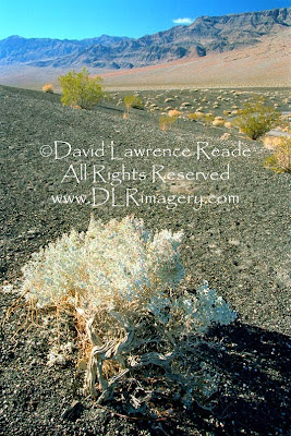
But Death valley has its own kind of unique beauty – the earth laid bare revealing bands of pastel colors running through the rock walls of the surrounding mountains – in places it resembles different flavors of ice cream layered on top of each other if one uses a little imagination.
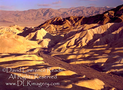
At sunset and sunrise, when the low sun accents the colors, the effect can be quite stunning. Sand dunes also stand out during the magic hours of dawn and dusk, taking on a warm glow with long shadows accenting their textures.
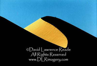
So why do I find myself in a motel again tonight, outside of the park? Because, believe it or not, it is pouring relentlessly and all the roads in the park are closed due to flooding (and snow and ice at higher elevations.) What? In Death Valley? The place where the 1.9 inch annual rainfall is greatly exceeded by an evaporation potential of 150 inches per year? Yes, I have timed my arrival perfectly (not.)

Guess I’ll have to enjoy the relative comfort of a motel room for one more night and see what tomorrow brings. It’s not like I have a choice, my next destination is the Owens Valley and it is only accessible from here, at this time of year, by traversing Death Valley.

Next: Ghost Towns and Snowplows (say what?)

Thursday, July 30, 2009

Desert Daze: A Southwest Adventure (XX)

Part Twenty (finally!): Red Rock Canyon vs. Bryce Canyon

(First time reading this 'Desert Daze' story? Scroll down to 'Older Posts' to start with Part One)

Well, there really shouldn’t be a ‘versus’ in the title, both places are equally spectacular and feature some of the same red, pink and orange rock formations. But in terms of visitation, and despite being only about ten miles apart, they may as well be a million miles away from each other. Bryce’s National Park status and easy access make it a favorite of the tourist crowd, often scurrying right through Red Canyon to get there.

A mistake, in my opinion. I’ve been to Bryce several times before, done the tourist thing - visited all the overlooks and taken several of the recommended hikes. But, because of its popularity, it doesn’t have any feeling of wilderness or solitude, it’s got that ‘Disney-esque’ atmosphere that many of the National Parks have. So this time around, I choose Red Canyon. Although its access is right off the main highway, the minute I hike beyond the sight and sounds of the road, I am in pure solitude; I spot not another single person the rest of the day.

It’s chilly here at 7,500 feet and scattered snow patches contrast nicely with the vivid reds. I start hiking to the top of a ridge to gain sweeping views into the canyon; it’s slow going in the shifting red sands at this elevation. When I finally reach the top, I am breathing heavily. I stop, catch my breath and marvel at the splendor spread out before me.

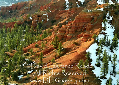
The sand resulting from the erosion of the rock settles smooth creating an unreal-looking soft landscape of rich color and sexy silkiness (if rocks and sand can ever be sexy and silky, they are here, or maybe I’ve just been out here alone for too long.) It is a dreamscape, almost too beautiful to be true. Yet another place to come back to; to explore in more depth on a future trip.

Next: The Torrential Rains of Death Valley

Saturday, June 20, 2009

Hike For Health

It’s too beautiful of a night not to get out into the woods – not too hot, not too cool - just right. Ambling over hill and dale, I jump over fallen trees, dodge scratchy branches and watch for ankle-twisting woodchuck holes – a natural obstacle course if you will.

This is excellent exercise, not just for the heart and muscles, but for coordination and mental alertness as well. It occurs to me that hiking like this is a great activity for overall fitness, one that just about anyone can do at their own pace. And this is not to mention being given the privilege of beholding some of Mother Nature’s finest while doing it - lush foliage, gorgeous wildflowers, magical encounters with our forest friends, heartbreakingly beautiful birdsongs and the incomparable sweet and oxygenated fragrance of the forest to mention a few.

If it’s been a while since I last visited one of these sylvan cathedrals, I start to feel disconnected from the world around me. But as soon as I enter the woods, I’m renewed, at once both in touch with the cosmos again but freed of its challenges and problems, at least for now. Surrounded by forest, I am somehow incapable of worry.

When I see or hear that another one of these sacred places is being scalped and bulldozed in favor of a few who would profit and/or to support an ever soaring human population and its crushing footprint, I get sad. Once a forest ecosystem has been obliterated, it will be a long, long time (if even ever given the chance), until it returns to its former glory - certainly not in our lifetimes.

Sadly, every last scrap of woods that I grew up exploring in as a child is long gone. With suburban sprawl pushing out further and further, forestland is disappearing at an alarming rate - so I hike that which remains whenever I get the chance. Developers don’t seem to have learned what I have in this life: money in itself cannot bring happiness – I’ve been both well-off and poor – but a simple jaunt in the woods can. I’ve never not felt better, physically, mentally and spiritually, after a hike than before. I hike for my health!

Coming soon: Desert Daze - A Southwest Adventure: Part Twenty

Monday, June 1, 2009

Desert Daze: A Southwest Adventure (XIX)

Part Nineteen: Canyon Squall

I am told that there are some incredible hikes in the contorted landscape that is the Waterpocket Fold, but for now I only have eyes for a warm bed and shower and it’s already mid afternoon. I add this area to my getting-very-long list of places to get back to, to settle in and explore at length – there’s so much out here to explore - I hope I live to 100 (yes, I’ll still be hiking, albeit maybe a little bit more slowly)!

For now though, I must keep my weary eyes on the road as it twists and turns through Long Canyon. Suddenly, I find myself in a snow squall and the road an icy sheet. I better put the truck into 4-wheel drive. Oops, I don’t have 4-wheel drive this time - I’m so used to having it both at home and on these adventures that I forgot momentarily that I don’t have it on this trip.

Warily creeping down the slippery canyon road, the truck slips and slides but I manage to stay out of the ditches. As I slowly descend in elevation, the squall diminishes and finally disappears and I am once again on dry pavement. Relief.

I cross a bridge over a small, but energetic stream coming out of the cliffs above; it looks intriguing. I pull over to investigate. As I get out of my vehicle, a group of cattle eye me warily, then snort and crash away into the lush undergrowth. They must love it here, I think, lots of vegetation to eat (and trample) and plenty of water to drink (and befoul.) I hope that the people living and exploring down stream from here realize these cattle are up here fouling the waters, Guardia is a nasty thing, causing long-lasting diarrhea and dehydration.This creek (and several others I am about to cross) are tributaries to the Escalante River, meaning that the water of the Escalante is definitely not safe to drink.

I finally reach the tiny town of Boulder (Utah, population: 178.) Not finding suitable accommodations here, I decide to head south to the town of Escalante (population: a whopping 818 persons.) To get from Boulder to Escalante, one must drive the “Million Dollar Road”; a section of Scenic Byway 12 that was built by the Civilian Conservation Corps and completed in 1935 (paved in 1971) providing the first year round access for automobiles to this isolated pocket in southwestern Utah. Before then, mail and supplies were carried to Boulder by mules and pack horses over Hell’s Backbone or the Boulder Mail Trail, both hazardous routes.

One segment of this route, over ‘The Hogback’ is, in my opinion, the scariest section of paved road in Utah. (I have to qualify this statement with ‘paved’ because there is no shortage of scary and even downright terrifying unpaved roads throughout Southern Utah for the truly adventurous.)

There is little margin for error when driving ‘The Hogback’ section; it’s a narrow, winding road with steep drop-offs down into Calf Creek Canyon on one side and Boulder Creek Canyon on the other starting just feet from the sides of the road. The views are incredible, but, unless you’re a passenger, don’t even be tempted to glance at them while driving; instead, wait for a pullout where you can safely drink in the expansive panoramas of sandstone country surrounding you.

One of my favorite places in the area to visit is Calf Creek Falls (pictured above), a 126-foot cascade in a lush, enchanting grotto with a deep pool surrounded by shade trees. It’s quite a contrast to the thirsty country around it. On the way to the falls, large pictographs can be seen high up on the opposite canyon wall – but what I want to know is just how did they get up there to paint them, they must be at least 50 feet up?

Next: Red Rock vs. Bryce Canyons

Sunday, May 17, 2009

Desert Daze: A Southwest Adventure (XVIII)


Part Eighteen: Holy Sh*t, You’ve Got To Be Kidding Me, The Road Goes Where?

I find out later when looking at my map that I’ve been driving on the Notom-Bullfrog Road. Gotta love the names of some of the roads around here: Notom-Bullfrog (goes to Eggnog Junction!) Hole-in-the-Rock. Moody Canyon. Lampstand. Nipple Creek. Death Ridge. Left Hand Collet. Carcass Wash. Etc. All very descriptive and I’m sure, with some interesting stories behind them.

I looked into a couple of the names when I returned home from the trip. Turns out Left Hand Collet Road simply refers to one of two canyons (Left Hand and Right Hand Collet) that merge into Collet Canyon; not too exciting. Carcass Wash Road however, refers to the bodies of cattle that are found in the road after attempting to cross this steep wash and not making it. Turns out this steepness has created some human carcasses too. In 1963 a party of 49 people, including members of a Scout Troop, were heading to a boating trip down the Colorado River here (before it disappeared under the waters of Lake Powell) when the truck they were riding in lost power while climbing out of the wash, and then lost its brakes. It rolled back into the bottom, killing 13 adults and children.

Driving Notom-Bullfrog Road north, I am lost in reverie, consumed by the extreme beauty all around meand almost miss the road heading off west to Boulder.
I turn, but then realize it heads right up the massive wall of the Waterpocket Fold. Uh-oh. I see no warning signs indicating that this is four-wheel drive only, so I continue on. It is an admittedly very well maintained road, but still, it is gravel, only one vehicle wide in places, and heading straight up. And, just to keep things interesting, there are patches of snow and ice on the switchbacks near the top. And no guardrails. Arghhhhh!

Once committed though, there is nothing to do but keep pushing upward (can’t even imagine trying to back down.) I stop at one of the switchbacks near the top to look down at where I have just come from – whoa!, this is one steep mother of a road – it looks to be almost straight down from here.

Oops, now someone in a jeep is coming down at me from the top and I’m blocking the road. I have stopped at the edge of a snow patch - not too smart. I try to get going again and only succeed in spinning the tires, moving the truck sideways towards the edge. I’m scared. I think I need to change my underwear scared. I back up to dry pavement and try again; this time I gain enough purchase and momentum to make it through the snow patch and to dry pavement on the other side. Whew! I pull over in a wider section and let the Jeep pass me. The occupants are two women, apparently out looking for adventure like me. It's not too often I see women in remote areas like this. They look at me wide-eyed, probably thinking something like “this guy is totally nuts coming up here in that van” but they smile and wave. Naturally, I smile and wave back trying to appear nonchalant, trying to keep the terror off my face.

Of course, you knew I made it or I wouldn’t be telling this story. According to what I've since read, this road on this steep, 600-foot slickrock and scree slope is the only relatively easy crossing over the entire southern Waterpocket Fold. (Harrumph. If you had tried to tell me a few minutes ago when my heart was beating faster than a hummingbird’s wings (that's about 50 times per second) that it’s a ‘relatively easy’ crossing, I would have taken issue!)

I pull over at the top to gather my wits . I look back: an incredible view of classic desert scenery and mountains. Up here, the weather is different; there are patches of snow scattered about and the wind is bitingly cold. I am on the Burr Trail, named after John Atlantic Burr, who was born in 1846 aboard the SS Brooklyn somewhere in the Atlantic Ocean. He and his family lived in Salt Lake City, then later moved south and established the town of Burrville, Utah, in 1876. The route was probably initially used by American Indians, but John Burr further improved it to move cattle back and forth between winter and summer ranges and to market. This cattle trail through the rough, nearly impassable country around the Waterpocket Fold, Burr Canyon, and Muley Twist Canyon eventually came to be known as the Burr Trail.

And said Burr Trail will get me to Boulder, eventually - it’s not done with me yet!

Next: Canyon Squall

Thursday, May 14, 2009

Desert Daze - A Southwest Adventure (XVII)

Part Seventeen: Ticaboo Town, Pedestal Alleyway and the Great Wall

(Story continued from the April 28th posting. not the May 1st one.)

It’s a miracle - the fumes of the fumes get me to Ticaboo. And there are gas pumps here – Hooray! Turns out Ticaboo isn’t really so much a town as it is an all-in-one resort complex. It was established in the 70’s as another uranium mining town, but now relies on tourism business due to its relative proximity to Lake Powell (about eleven miles from here.) So here, in the middle of desolate nowhere, you’ll find everything you could possibly need – a store, deli, motel, tavern and, of course, gasoline. It’s probably a hoppin’ place in the summer, but now, in winter, the store looks closed. Oh no, now what do I do? But when I see that the gas pumps operate 365/24/7 by credit card, relief floods through me. Hooray indeed!

Flush with gas (the truck, not me), I continue south towards the lake. I spy a road labeled as a ‘Scenic Backway’ heading off towards the west. A sign indicates that this road will take me to the little town of Boulder and that’s exactly where I want to go - I desperately need a shower. So, if this road will get me to Boulder and someone thinks it’s scenic, that’s enough for me; I turn.

The road turns to dirt after a few miles but it is well-graded - so far. Dipping down into a ravine, I see a ‘Road Closed’ sign at the side of the road. Evidence in the form of eroded road bed and still-wet earth high up on the banks of the gully show why it was closed - the creek running through it had obviously recently flash flooded. Fortunately, the water is now low enough for me to ford it; I push on despite the little voice in my head questioning whether that’s a good idea. I tell the voice to shut up - after all, that’s what I’m here for - adventure!

Whoever designated this road scenic sure got it right. Grand walls of layered limestone accented by red striped mounds lying at its base rise monumentally in front of me as far as I can see.
Turns out this wall of rock I am driving next to is the ‘Waterpocket Fold’, a long warp in the Earth's crust. It’s a monocline: a regional fold with one very steep side in an area of otherwise nearly horizontal layers. A monocline is a "step-up" in the rock layers; the layers on the west side of the Waterpocket Fold have been lifted more than 7000 feet higher than the layers on the east. Major folds are almost always associated with underlying faults. The Waterpocket Fold formed between 50 and 70 million years ago when a major mountain building event in western North America, the Laramide Orogeny, reactivated an ancient buried fault. When the fault moved, the overlying rock layers were draped above the fault and formed a monocline. However it was formed, it’s impressive – essentially a ‘Great Wall’ of rock that stretches for nearly 100 miles!
On my right, a trailhead sign whizzes by. I turn around to investigate - the trail leads to the ‘Pedestal Alleyway’, a small canyon full of hoodoos.
By now, you’d think I’d have had enough of hoodoos but I can’t resist. The hike is tough going; it’s through disturbed desert (cattle grazing – I’ll say it again, what in the heck are cattle doing grazing in the desert?), a painfully slow slog through loose sand. I realize that my legs are still very tired from all the ambitious hiking I’ve been doing and that has, combining with not drinking enough water, reduced my legs to little more than wobbly wet noodles.

I finally make it to the 'alleyway' and it's an intriguing place. All varieties of hoodoos have ‘sprouted’ here in this little canyon - short ones, tall ones, skinny ones, fat ones and even some that strikingly resemble a certain part of a man’s anatomy, if you get my drift.
But I have to admit that by now I have seen so many of these rock peculiarities that I am a little hoodoo'ed out. I shoot a few shots and then begin the long slog back. Lift foot, move it forward, put foot down, now the other. This is the way I’m feeling, like every step is a process. I’m so very tired of hiking through energy-sapping sand.

Finally, back at the truck, I wolf (why wolf, why not coyote?) down some peanut butter and jelly (no bread) and drink at least a half a gallon of water. This refreshes me both physically and mentally and I am now ready for more adventure – well, maybe only of the driving kind for the rest of this day.

Next: Holy Sh*t, You’ve Got To Be Kidding Me, This Road Goes Where?

Tuesday, May 12, 2009

Patience please...

With art show season upon me (for those who don't know, I exhibit my photography at outdoor art shows spring thru fall), posts will be a little more sporadic, generally about once a week. Part 17 will be posted later this week. Please keep checking back! And post any comments you have, lets get some dialog going.

Thanks so much for your interest!